Location
Panay is one of the 16 municipalities in the Province of Capiz located in the Region VI, Western Visayas with coordinate 11 28'55.79" latitude, 112 47'46.30" longitude, 11 36'28.74" latitude, and 122 47'59" longitude. It is along the coastal areas of Northern Panay Island with Roxas City on the northwest, Sibuyan Sea on the northeast, the Municipality of Pontevedra and Panitan on the south, and the Visayan Sea on the southeast
Municipality Of Panay
Land Area
Panay has a toal land area of 13,863.16 hectares including 1,079.02 hectares as newly registered foreshore and accretion by the sea. It represents 4.45% of the total land area of the province. Panay is composed of 42 barangays.
In terms of land area, Brgy. Pawa is the largest barangay with 1,899 hectares (14.86%) while Brgy. Poblacion Ilawod is the smallest with 14.93 hectares (0.12).
In terms of land area, Brgy. Pawa is the largest barangay with 1,899 hectares (14.86%) while Brgy. Poblacion Ilawod is the smallest with 14.93 hectares (0.12).
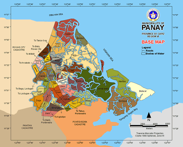
Municipal Map
Climate
The Philippine Atmospheric Geographical and Astronomical Services Administration (PAG-ASA) classifies all the towns of Capiz as Type 3 Climate (Coronas Classification System). Seasons are not very pronounced in Type 3 Climates. However, rainfull distribution is relatively dry from November to April and very wet during the rest of the year. Driest month is April while the wettest month is June. the dry northeast wind(amihan) causes the dry season while the southeast monsoon(habagat) brings the wet season due to its humid air that drops off rain during the rest of the year.
The natural hydrological system makes the municipality less prone to flooding however heavy rain downpour can cause inundation of low areas such as Brgy. Bago Grande, Linao and Lus-onan. In general, the climatic conditon of the municipality is suitable to agri-fishery.
The natural hydrological system makes the municipality less prone to flooding however heavy rain downpour can cause inundation of low areas such as Brgy. Bago Grande, Linao and Lus-onan. In general, the climatic conditon of the municipality is suitable to agri-fishery.
Topography
Panay is relatively flat with 0-3% slope consisting 97.8% of the total municipal land area. A small portion in Brgy. Bato and Binangig has a slope of 3-5% consists the 2.2% of the total land area.
Access
Panay is accessible through any land transportation passing the Capiz East Road. From Roxas City, it can be reached via jeepney, tricycle or car in 15 minutes(7.5 km). From Iloilo, it takes about 2 hours and 30 minutes by bus or van(135 kilometers) while from Kalibo, Aklan, it takes about an hour (92 kilometers). From Manila, it takes 45 minutes by airplane to reach Roxas City Airport and 18 hours by ship to reach Culasi Port(1,600 kilometers).
Major Rivers
Napatasan River
Catmon River
Arellano River
Tanza River
Panay River
Agojo River
Sta. Monica River
Binantu-an River
Bantique River
Lanipga Rive
Labayon River
Takilid River
Nauruk River
Lomoc River
Bacaco River
Jamodlong River
Bagacay River
Navitas River
Jamul-awon River
Catmon River
Arellano River
Tanza River
Panay River
Agojo River
Sta. Monica River
Binantu-an River
Bantique River
Lanipga Rive
Labayon River
Takilid River
Nauruk River
Lomoc River
Bacaco River
Jamodlong River
Bagacay River
Navitas River
Jamul-awon River
